3D BIM MODELING SERVICES
3D BIM Modeling Services: Digital Integration and Coordination Power in Infrastructure Projects
Dotasal Proje Mühendislik effectively uses 3D BIM (Building Information Modeling) technology in infrastructure projects, overcoming the limitations of traditional 2D drawings. BIM is an approach that increases engineering efficiency in design, implementation and maintenance processes, strengthens visual coordination and maximizes field applicability. This text describes in detail the 3D BIM modeling services, processes, benefits and application areas of Dotasal Proje Mühendislik.
What is BIM?
Building Information Modeling (BIM) is an object-based modeling system that represents all the physical and functional elements of an infrastructure project in a digital environment. BIM is not just about 3D geometric drawings; it integrates multidimensional data of each project element, such as material properties, performance data, cost information and life cycle. In this way, data sharing and coordination between project stakeholders are ensured and project processes are optimized. Dec.
The main components of BIM are:
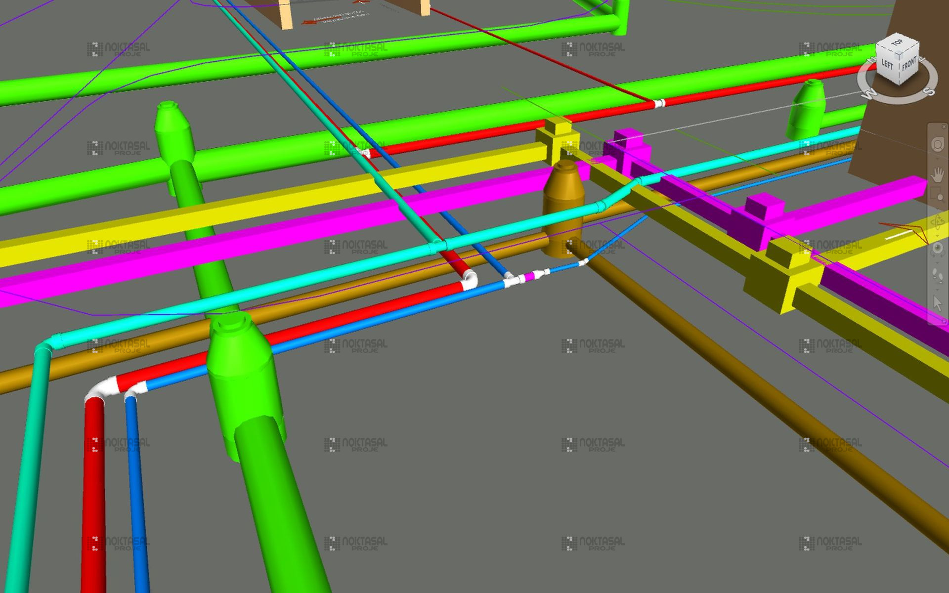
- Geometric Modeling: 3D representation of project elements (pipes, manholes, road layers, etc.).< / li>
- Information Integration: Technical characteristics of the elements (diameter, material, slope, capacity).< / li>
- Life Cycle Management: Tracking of design, construction, operation and maintenance processes in a digital environment.< / li>
- Stakeholder Coordination: Integrated work with architectural, static, mechanical and electrical disciplines.< / li>
Why Do We Use 3D BIM?
Pointwise Project Engineering offers significant advantages compared to traditional methods by integrating 3D BIM technology into infrastructure projects. Here are the main benefits of BIM in infrastructure projects:
1. Conflict Detection (Clash Detection)
In infrastructure projects, drinking water, sewage, stormwater, electrical and mechanical systems usually move along the same corridors. BIM detects potential conflicts between these systems at the design stage.Dec.1.BIM detects potential conflicts between these systems at the design stage. For example:
- The minimum vertical/horizontal distance between drinking water and sewer lines is provided.Dec.< / li>
- The intersection points of the road infrastructure and pipelines are analyzed.< / li>
- Conflicts are resolved before field application and costly revisions are prevented.< / li>
2. Improved Coordination
BIM provides seamless coordination between different disciplines (architecture, static, electrical, mechanical).Dec. Infrastructure routes are modeled in such a way that they are compatible with the superstructure elements. This makes it possible for project stakeholders to work on a common digital platform.
3. Visualization and Communication
BIM models visualize complex infrastructure systems in a 3D environment, making them understandable for project teams and administrations. Perspective visuals, animations and interactive models guide field teams while providing effective communication to administrations in the presentation processes.
4. Excavation-Filling Optimization
BIM allows for integrated elevation analysis with line depths, road elevations and other infrastructure systems. Thanks to this:
- Excavation volumes are minimized.< / li>
- Routes suitable for the topography are determined.< / li>
- Excavation and filling costs are optimized.< / li>
5. Field Application Guide
Sections, detail sheets and labeled images obtained from BIM models serve as a direct guiding guide for field teams. Coordinated drawings and 3D models reduce the risk of errors during application.
6. Ease of Operation and Maintenance
BIM facilitates maintenance and operation processes throughout the life of the facility by creating a digital twin of infrastructure systems. For example:
- Information such as pipe diameters, manhole positions and valve types are stored digitally.< / li>
- Quick access to system elements is provided in case of malfunction.< / li>
- The current model is used for renovation or expansion projects.< / li>
Our BIM Application Areas
Dotasal Proje Mühendislik provides 3D BIM modeling services in infrastructure projects in the following disciplines:
Drinking Water Network
- Modeling Scope: Ring lines, branches, valve chambers, meter boxes, water tanks and pumping stations.ations.< / li>
- Technical Specifications: Integrated modeling with pressure zones, elevation relations and hydraulic anulic analysis.< / li>
- Benefits: Compliance of network elements with topography, conflict prevention and sensitivity in field applications.ations.< / li>
Sewage (Wastewater) System
- Modeling Scope: Gravity wastewater lines, collectors, manholes, directional change chimneys and parcel connel connections.< / li>
- Technical Specifications: Slope analysis, flow capacities and coordination with the tr the treatment plant.< / li>
- Benefits: Compatibility of the wastewater system with superstructure and other infrastructure systems, simplification of maintenance processes.cesses.< / li>
Stormwater Drainage System
- Modeling Scope: Surface grids, manhole structures, collector lines, leakage and storage sorage systems.< / li>
- Technical Specifications: Slope/slope analysis integrated with road elevations, flood risood risk assessments.< / li>
- Benefits: Efficient operation of the drainage system, sustainable solutions in stormwater management.gement.< / li>
Road and Superstructure
- Modeling Scope: Road layers (PMT, binder, wear), curbside, treatment, intersection and parking lot dg lot designs.< / li>
- Technical Specifications: Migration solutions at infrastructure conflict points, traffic flowic flow optimization.< / li>
- Benefits: Compatibility of road infrastructure with other systems, aesthetic and functional design.design.< / li>
Our 3D BIM Process
Dotasal Proje Mühendislik conducts the 3D BIM modeling process in a systematic and structured way. Our process includes the following steps:
Data Collection and Terrain Modeling:
- Numerical maps, topographical data, geological reports and existing infrastructure information are collected.< / li>
- A digital terrain model (DTM) is prepared and a 3D representation of the project site is created.< / li>
3D Layout of Line Routes:
- Drinking water, sewage, stormwater and road systems are modeled in a 3D environment in accordance with technical standards.< / li>
- Routes are optimized to be compatible with topography and other infrastructure systems.< / li>
Conflict Control:
- Using software such as Autodesk Navisworks or Revit,conflicts between systems are analyzed Decently.< / li>
- Design revisions are made by ensuring minimum vertical and horizontal distances.< / li>
3D Sheet Production:
- Sections, views, perspective images and labeled detail sheets are automatically generated from the BIM model.< / li>
- The sheets are delivered in a format in accordance with the standards of the administrations.< / li>
Presentation and Approval Process:
- 3D visuals, animations and interactive models are prepared to be presented to the administrations.< / li>
- Meetings are organized with project stakeholders and feedback is received through the model.< / li>
Application Support and BIM Delivery:
- Coordinated drawings, 3D models and application guides are delivered to the field teams.< / li>
- The BIM model is shared in digital format (IFC, RVT) for operation and maintenance processes.< / li>
Why Point-to-Point Project Engineering?
- Expert Staff: Our experienced engineers in the field of BIM modeling and infrastructure engineering add value to your projects.ojects.< / li>
- Innovative Approach: By using the latest BIM technologies and software, we offer industry-leading soling solutions.< / li>
- Customer Orientation: We develop solutions specific to project needs, cooperate closely with administration antion and field teams.< / li>
- Sustainability: We produce efficient and long-lasting infrastructure designs that minimize environmental impacts.mpacts.< / li>
Result
Dotasal Proje Mühendislik carries out digital transformation in infrastructure projects in a leading way with 3D BIM modeling services. BIM technology improves the design quality of our projects, reduces costs, speeds up implementation processes and maximizes operational efficiency. Contact us to benefit from the power of BIM in your infrastructure projects!